Survey of TV Meteorologists on Climate Change March 30, 2010
Posted by mikeheard in Uncategorized.add a comment
Survey of TV Meteorologists on Climate Change
More than half of the meteorologists working on TV believe global warming is happening. But most of them attribute that warming to natural changes in the environment, according to a new survey conducted by George Mason University.
571 members of the American Meteorological Society and the National Weather Association answered the poll between January and February 2010. The results indicate 54% believe global warming is real, 25% said it’s not happening and 21% still don’t know for sure.
Assuming global warming is happening, only 31% said human activities were the cause while 63% indicated the warming is part of natural process.
The term “scientific consensus” is used a lot when discussing climate change, but the majority (61%) of TV weathercasters think there is a lot of disagreement among scientists about whether global warming is real.
Only 44% indicated they trust the Intergovernmental Panel on Climate Change even though the AMS and others point to the IPCC as an empirical source on climate change. Opinions might have been swayed by the recent admission by the IPCC that some of their data is not accurate.
Instead of the IPCC, more than 80% of TV weathercasters turn to their state climatologists for honest information about global warming. NOAA and the National Weather Service are also trusted sources. Not surprisingly, politicians, religious leaders and other mainstream news media ranked the lowest.
48% of TV meteorologists say global warming hasn’t affected local weather patterns. But the issue is a concern for the public; 87% indicated the subject comes up while speaking to community groups.
About a third of the respondents said they’ve discussed climate change on blogs and during daily weathercasts. 79% said stories about climate change should include a balance of opinions, similar to how politics and other social issues are covered.
Spring Snow Storm Hits Today! March 30, 2010
Posted by mikeheard in Uncategorized.add a comment
3:30pm
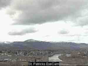
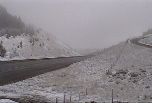
Look at the web camera pictures below, it’s snowing hard on the MSU campus with only flurries over the Bozeman pass I-90.
2pm adding ICAM pictures from around MT. Notice Bozeman appears to be the target for moderate to heavy wet snow this afternoon. NWS snow report so far: Brackett Creek Snotel 14 miles NE of Bozeman 9″ of new snow over the last 12 hours at an elevation of 7,320′.
Strong cold front hit Montana overnight with strong winds and now that we are behind the front and the flow aloft has changed to the NW cooler air is moving in and rain has changed to snow for many locations.
Mountain passes are baring the brunt of the snow and take a look at the 8am MDOT camera’s.
URGENT - WINTER WEATHER MESSAGE
NATIONAL WEATHER SERVICE GREAT FALLS MT
808 AM MDT TUE MAR 30 2010

MTZ008-015-055-301830-
/O.NEW.KTFX.WW.Y.0017.100330T1408Z-100330T1800Z/
/O.CON.KTFX.WS.W.0003.000000T0000Z-100331T1200Z/
BEAVERHEAD-MADISON-GALLATIN-
INCLUDING THE FOLLOWING LOCATIONS...BIG HOLE PASS...DILLON...
MONIDA PASS...ENNIS...TWIN BRIDGES...RAYNOLDS PASS...BOZEMAN...
BOZEMAN PASS...WEST YELLOWSTONE...TARGHEE PASS
808 AM MDT TUE MAR 30 2010

...WINTER WEATHER ADVISORY IN EFFECT UNTIL NOON MDT TODAY FOR
ELEVATIONS BELOW 6500 FEET...
...WINTER STORM WARNING REMAINS IN EFFECT UNTIL 6 AM MDT
WEDNESDAY FOR ELEVATIONS ABOVE 6500 FEET...

THE NATIONAL WEATHER SERVICE IN GREAT FALLS HAS ISSUED A WINTER
WEATHER ADVISORY FOR ELEVATIONS BELOW 6500 FEET FOR SNOW...WHICH
IS IN EFFECT UNTIL NOON MDT TODAY. A WINTER STORM WARNING FOR
ELEVATIONS ABOVE 6500 FEET REMAINS IN EFFECT UNTIL 6 AM MDT
WEDNESDAY.

* TIMING AND MAIN IMPACT: MOUNTAIN SNOW WILL CONTINUE ACROSS
  SOUTHWEST MONTANA TODAY...AS SNOW DEVELOPS IN THE VALLEYS THIS
  MORNING BEFORE CHANGING BACK TO RAIN THIS AFTERNOON. SNOW LEVELS
  WILL GRADUALLY RISE THIS AFTERNOON BEFORE FALLING AND REACHING
  THE VALLEY FLOORS TONIGHT. HEAVY WET SNOW MAY CREATE HAZARDOUS
  TRAVEL CONDITIONS...ESPECIALLY THROUGH MOUNTAIN PASSES. ISOLATED
  THUNDERSTORMS ARE ALSO POSSIBLE THIS AFTERNOON...WHICH MAY CAUSE
  BRIEF HEAVY SNOW SHOWERS.

* SNOW ACCUMULATIONS: 8 TO 15 INCHES OF WET SNOWFALL ARE GENERALLY
  EXPECTED ABOVE 6500 FEET THROUGH THE PERIOD...WITH 2 TO 4 INCHES
  IN THE VALLEYS BELOW 6500 FEET THROUGH LATER THIS MORNING.
  ISOLATED HIGHER AMOUNTS ARE POSSIBLE NEAR RIDGE TOPS.

* ELEVATIONS: WINTER STORM WARNING FOR ELEVATIONS ABOVE 6500 FEET.
  WINTER WEATHER ADVISORY FOR ELEVATIONS BELOW 6500 FEET.

* OTHER IMPACTS: SOUTHWEST WINDS OF 20 TO 25 MPH WITH GUSTS TO
  35 MPH MAY CAUSE REDUCED VISIBILITIES IN BLOWING SNOW AT
  TIMES.

* LOCATIONS AFFECTED INCLUDE: BOZEMAN...BOZEMAN PASS...WEST
  YELLOWSTONE...TARGHEE PASS...BIG HOLE PASS...DILLON...
  MONIDA PASS...ENNIS...TWIN BRIDGES...RAYNOLDS PASS

PRECAUTIONARY/PREPAREDNESS ACTIONS...

A WINTER STORM WARNING MEANS SIGNIFICANT AMOUNTS OF SNOW ARE
EXPECTED OR OCCURRING. STRONG WINDS ARE ALSO POSSIBLE. THIS WILL
MAKE TRAVEL VERY HAZARDOUS OR IMPOSSIBLE.

FOR SPECIFIC ROAD AND TRAVEL CONDITIONS IN MONTANA...DIAL 5 1 1.

&&

$$


